

The Wales Coast Path runs straight through Abersoch, and that is the village's best feature for walkers. You do not need a car to start: from the harbour or the main beach you can join the path in either direction, and within an hour you can be on heathland above Cardigan Bay, on a quiet beach with no facilities, or walking into a different village for lunch. This guide covers the five best Wales Coast Path routes from Abersoch, on the south coast of the Llŷn Peninsula in Gwynedd, North Wales — not Aberdovey (Aberdyfi), a different village much further south.
All five routes use the Wales Coast Path, the national trail around the Welsh coast, of which the Llŷn Peninsula section is one of the most varied: sheltered bay beaches, high heathland headlands, secluded coves to the south, and long sandy beaches to the north-east. Distances below are given where an official or widely published source states them; where sources disagree, the range is given and flagged for checking. Times are walking times only — add stops, cafés and tide waits on top.
Before you walk: tides, transport and kit
Three points apply to every route here. First, check the tide. Several sections use the beach — Warren Beach into Abersoch, the beach walk to Machroes, and the sands at Llanbedrog and Pwllheli — and at high tide the main beach narrows and some smaller stretches largely disappear. Second, plan your return. The classic Abersoch walks are linear: you walk to Llanbedrog, Pwllheli or Porth Ceiriad and come back on foot, by bus, or by a lift. Rural buses are infrequent and seasonal, so check timetables before relying on a bus home; walking back doubles the distance. Third, carry a map and water, and wear boots rather than beach shoes beyond the village circuit. Phone signal is patchy on remoter stretches, Porth Ceiriad has limited signal and no facilities, and the path can be muddy, steep and exposed after rain.
Dogs are welcome on much of the path, under close control near livestock, cliff edges and beach restriction zones. The main beach has seasonal dog restrictions, while Machroes, Warren, Porth Ceiriad and Hell's Mouth are reported as dog-friendly all year round — see our beaches guide and check the signs.
Route 1: Abersoch harbour, village and Machroes — the easy starter
What it is
The shortest walk in this guide, and the right first walk for any visitor: a circuit of the harbour, the village centre and the beach to Machroes, all on the flat or on sand. Start at the harbour, walk through the village centre on Stryd Fawr, then join the main beach and walk along the sand to Machroes at its far end, where there is a beach café, a toilet block and a small car park. Return the same way, or by the road.
Why walk it
It teaches you Abersoch's geography in an hour: the harbour, the main beach, the yacht club headland, the Warren in the other direction, and the difference between the sheltered bay beach and the working harbour. It is also the walk to do with children, with a pram on the road sections, or on an arrival afternoon. The Machroes café is a natural turnaround point.
Practical notes
Easy and flat, widest and easiest at low tide. Allow about an hour with stops. No transport needed — it starts and ends in the village.
Route 2: Abersoch to Llanbedrog — the classic half day
What it is
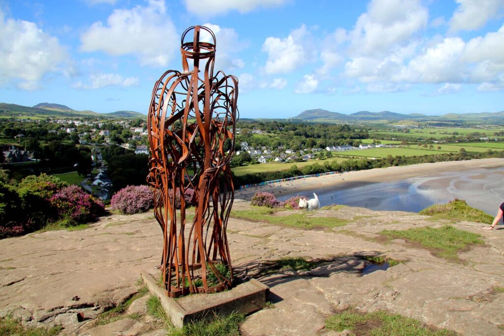
The single best walk from Abersoch. The Wales Coast Path's own itinerary gives this section as 4 miles (6 km) one way, from Llanbedrog to Abersoch — walked in reverse, from Abersoch, it is the same distance. From Abersoch, walk along Warren Beach north-east from the harbour, climb by steps onto the headland of Mynydd Tir-y-Cwmwd, cross protected heathland rich in gorse and heather, pass the Iron Man sculpture at Trwyn Llanbedrog above Cardigan Bay, then drop down into Llanbedrog village, with its sandy beach, colourful beach huts and National Trust car park.
Walked from Llanbedrog, the route starts at Plas Glyn-y-Weddw, the Grade II listed Victorian mansion and arts centre, and offers a choice: the steep woodland path through the Plas grounds, or the shoreline path, with both meeting at the viewpoint at Trwyn Llanbedrog. Either way, the Iron Man and the heathland are the highlights, and the views back over Abersoch Bay and across to Snowdonia (Eryri) are the best coastal views near the village.
Why walk it
It packs beach, headland, heathland, sculpture, a gallery and tearoom at the Llanbedrog end, and a village to have lunch in into a half day. Fit walkers can do it as an out-and-back of about 8 miles; others can walk one way and take a bus or a lift back.
Practical notes
Moderate, because of the climb and steps — not distance. Allow a half day one way with stops, check the tide for Warren Beach, and take water: there is no café on the headland.
Route 3: Abersoch to Pwllheli — the full day north-east
What it is
The longer continuation of Route 2: keep walking past Llanbedrog to Pwllheli, the peninsula's main town, with its marina and railway station. Published sources give this as about 8 miles one way, with one trail listing giving 8.1 miles and 3 to 3.5 hours of walking. The route runs from Abersoch along Warren Beach and over Mynydd Tir-y-Cwmwd to Llanbedrog, then along the beach past sand dunes and Pwllheli Golf Course into Pwllheli.
Why walk it
It is the walk for visitors who want a full day out and a town at the end of it: lunch, shops, the marina, and a railway station for the journey home if you do not want to walk back. The Llanbedrog-to-Pwllheli section on its own is described as just over 4 miles along the beach, so walkers who have already done Route 2 can treat Pwllheli as the next step rather than a leap.
Practical notes
Moderate, mainly because of distance and soft sand walking, plus the one climb onto Mynydd Tir-y-Cwmwd at the Abersoch end. Walking back means about 16 miles in total, so plan a return from Pwllheli — railway station and bus services, but check current timetables and do not assume a late bus exists. Take food and water, and check the tide.
Route 4: Abersoch to Porth Ceiriad — the secluded cove
What it is
The best walk south-east: shorter, wilder, ending at a beach with no facilities. Porth Ceiriad sits about 2.5 miles south-east of Abersoch, linked to the village by the Wales Coast Path, and one walking-app listing gives the Porth Ceiriad to Abersoch beach section as about 4.8 km (roughly 3 miles) taking about 1.5 hours. The path leaves Abersoch, rounds the headland past the yacht club, and follows the cliff-top grassy track towards Bwlchtocyn and the cove, with views over Cardigan Bay and St Tudwal's Islands for much of the way.
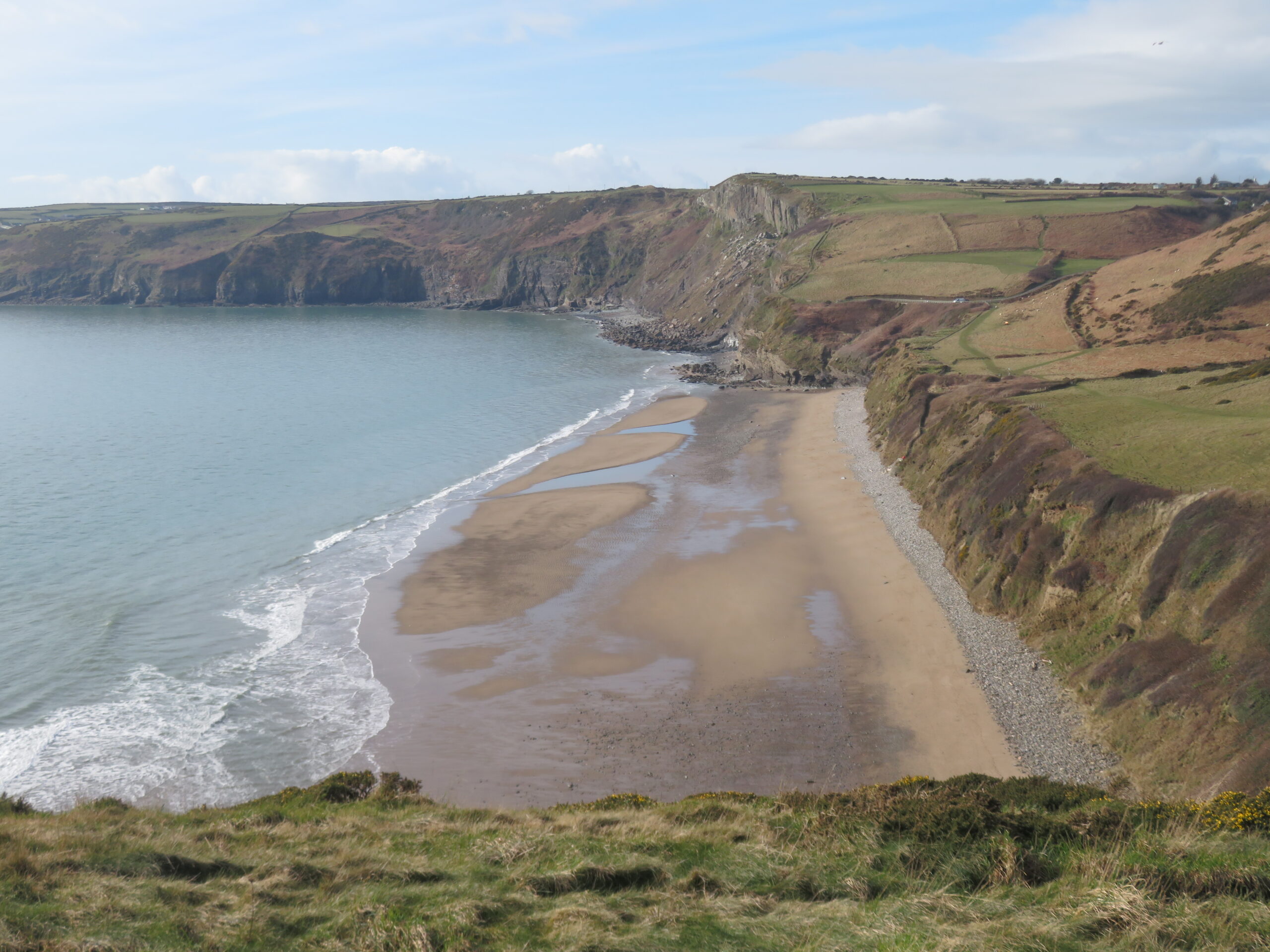
Porth Ceiriad itself is south-facing and sheltered, popular for surfing, bodyboarding, kayaking and sailing, with folded rock layers visible in the cliffs behind it. Access is by steep steps cut into the cliff, with large boulders at the top of the beach — challenging for prams or anyone unsteady on their feet, and the reason this route is graded moderate despite its modest distance.
Why walk it
It is the walk for visitors who want quiet more than convenience. After the busy main beach, Porth Ceiriad feels remote: no café, no public bins, limited phone signal, and a beach you have to earn by walking or by driving to a private car park and walking down. Bring everything you need and take all rubbish away.
Practical notes
Moderate, because of the cliff steps and exposed cliff-top sections, not the distance. Allow about 1.5 hours one way, and either walk back or arrange a lift from the Bwlchtocyn road end, where private car parks serve the beach. Do not attempt the steps in wet or windy conditions if you are unsteady. Rip currents have been reported at Porth Ceiriad, so treat it as a walking and paddling beach unless you know the surf conditions.
Route 5: Abersoch to Hell's Mouth (Porth Neigwl) — the big loop
What it is
The most ambitious walk in this guide: the full coastal loop from Abersoch around Porth Ceiriad to Porth Neigwl, known in English as Hell's Mouth, and back inland. A published loop listing gives this as approximately 10 to 11 miles (16 to 18 km) taking about 5 to 5.5 hours, over beaches, fields, cliff-top paths and some road sections, taking in Porth Ceiriad, Trwyn Cilan and the long sweep of Hell's Mouth.
Hell's Mouth is the Llŷn's main surf beach and picks up more swell than anywhere else in North Wales. It also carries a serious safety warning, repeated in our beaches guide: dangerous cliffs, currents and riptides, and swimming is not recommended. This is a walking and surfing route, not a swimming day out.
Why walk it
It is the walk that shows you the whole southern Llŷn coast in one day: the sheltered bay at Abersoch, the secluded cove at Porth Ceiriad, the high cliffs of the Cilan headland, and the wild open beach at Hell's Mouth. For experienced walkers it is the most rewarding route from the village; for everyone else it is the route to build up to, after Routes 1, 2 and 4.
Practical notes
Challenging, because of distance, rocky and sometimes rutted ground near Hell's Mouth, and exposed cliff sections. Allow a full day, start early, and carry a map, food, water and waterproofs — there are no facilities comparable to the main beach at Hell's Mouth, and only small car parks at the Llanengan end. Check the tide, keep well back from cliff edges, and do not enter the water there unless you are with a surf school or know the conditions. If the weather turns, cut the loop short at Porth Ceiriad.
Which route should you choose?
First walk or easy afternoon: Route 1. The one walk everyone should do: Route 2, Llanbedrog, 4 miles one way. A full day with a town at the end: Route 3, Pwllheli, about 8 miles one way. Quiet, secluded beach walking: Route 4, Porth Ceiriad, about 3 miles one way. Experienced walkers, a full day: Route 5, the Hell's Mouth loop, about 10 to 11 miles. Check the tide, check your return transport, and carry more water than you think you need.
FAQ
How long is the walk from Abersoch to Llanbedrog?
About 4 miles (6 km) one way, per the Wales Coast Path's own itinerary. Allow a half day with stops, and plan whether you are walking back or taking a bus or lift.
Can you walk from Abersoch to Pwllheli?
Yes, about 8 miles one way via Llanbedrog, taking roughly 3 to 3.5 hours. Plan your return from Pwllheli — walking back doubles it to about 16 miles.
Is the walk to Porth Ceiriad suitable for children?
Older children who can manage cliff-top paths and steep steps, yes. Not prams or anyone unsteady on their feet: the final beach access is steep steps with large boulders at the top, and there are no facilities there.
Can you walk from Abersoch to Hell's Mouth?
Yes, as a long loop of about 10 to 11 miles taking 5 to 5.5 hours, via Porth Ceiriad and the Cilan headland. It is a full-day walk for experienced walkers, and Hell's Mouth is not a swimming beach — it has strong currents and rips.
Are dogs allowed on the Abersoch coast path walks?
Generally yes, under control, especially near livestock and cliff edges. Machroes, Warren, Porth Ceiriad and Hell's Mouth are reported as dog-friendly all year round, while the main beach has seasonal restrictions, so check the signs.


